

ABNA24 - The US government has taken new measures to prevent the disclosure of damage to its bases during the war with Iran. The Trump administration has exerted fresh pressure on commercial satellite imaging companies to refrain from publishing high-resolution images of conflict zones, particularly in West Asia. This move should be analyzed as part of a systematic effort to control the narrative of the war and conceal the true extent of the damage caused by US attacks on Iran. It is not merely a technical or security decision, but also a tool for managing public opinion and covering up evidence of responsibility.
The first important aspect of this move is its intelligence and propaganda dimension. According to a New York Times report, in the early days of the war with Iran, satellite images revealed details of US missile strikes on civilian targets as well as damage inflicted on American military bases. The extent of this damage was greater than the Trump administration had acknowledged. This is precisely what explains the main motivation behind the restrictions: when independent images expose the gap between the official narrative and realities on the ground, controlling the flow of imagery becomes a means of bringing the official account into line with reality—or, more accurately, concealing that gap.
Planet Labs has informed its customers that it will restrict access to imagery at the request of the US government, while Vantor has also imposed similar restrictions, citing its internal policies. This simultaneous invocation of a “government request” and “company policy” indicates that, due to their heavy reliance on government contracts, these companies have effectively become implementing arms of the Trump administration’s concealment policy.
The second aspect is the geographical scope and unprecedented nature of these restrictions. According to the report, the restrictions now cover vast areas of the Persian Gulf, Gaza and Lebanon, including areas where US forces are not officially stationed. This is particularly significant because it suggests that the objective goes beyond protecting military personnel; it also involves preventing the documentation of damage to civilians and infrastructure across a wide geographical area. If the official rationale is concern that Iran could use commercial satellite imagery to identify the positions of US forces and target them, a serious question arises: why are areas with no official US military presence also subject to these restrictions? The logical answer is that the primary purpose of these restrictions is not operational security, but preventing independent verification of official accounts.
The third aspect concerns the consequences of this move for journalists, researchers and humanitarian organizations. The New York Times report emphasizes that the current restrictions make it more difficult to identify the nature of destroyed buildings and the types of weapons used in attacks. This means that precisely the information needed for investigations into potential war crimes, assessments of the needs of displaced people and refugees, and evaluations of the safety of camps is being made inaccessible. Notably, a tool developed in 2023 to monitor destruction in Gaza, which used European Space Agency imagery alongside high-resolution commercial US satellite images, is now losing its effectiveness as a result of these restrictions. This shows that the objective is not simply to block access to one source, but to disrupt the entire chain of documentation and independent verification.
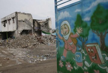
The fourth aspect concerns legal implications and accountability. When satellite imagery that has helped document incidents such as widespread destruction in Gaza and the attack on an elementary school in Minab on the first day of the Third Imposed War against Iran becomes inaccessible, the prospects for legal action and accountability for war-related damage are severely undermined. Concealing imagery effectively means concealing evidence, and concealing evidence can pave the way for impunity. This move should be viewed as part of the US approach to controlling information during wartime, whereby Washington seeks to reduce the political and legal costs of its military actions by restricting access to independent data.
It appears that what The New York Times has exposed is not merely a technical restriction on access to satellite imagery, but a sign of a deliberate strategy to conceal the damage caused by the war against Iran and control its narrative. This strategy pursues three objectives simultaneously: narrowing the gap between the official narrative and realities on the ground, preventing the documentation of potential war crimes, and reducing legal accountability.
The Trump administration’s approach calls into question the principles of transparency and independent access to information that Washington has long claimed to uphold. It also demonstrates that, in practice, shaping the narrative takes precedence over freedom of information and revealing the truth.
/129

Your Comment